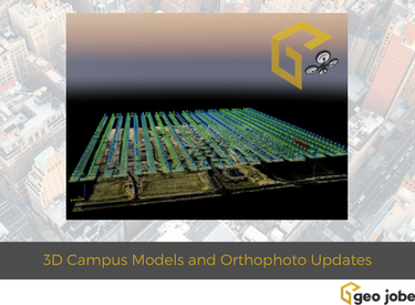
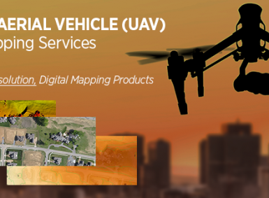
GEO Jobe is pleased to share that we offer high resolution low altitude orthophotography services (see geo-jobe.com/uav) and, optionally, hosting options via the GeoPowered Cloud. As part of our services, we are providing orthophoto planimetric mapping products including small area rectified mosaics, digital surface models (DSM), digital terrain models (DTM), and 3D models as well […]
Category: UAV
UAV, aerial mapping and drone technology

News – GEO Jobe UAV Secures Official FAA Authorization for UAV Mapping Flights on Airport Lands
GEO Jobe UAV Mapping services is conducting UAV/UAS operations at levels few other geospatial technology companies are having success at achieving. GEO Jobe UAV Mapping Services has beaten the odds to receive the hard to come by FAA airspace authorization for UAV missions on designated Airport lands.
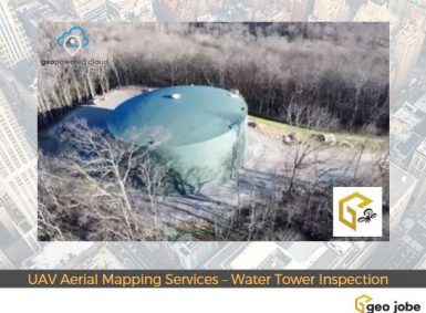
Geo Jobe GIS Consulting UAV Aerial Mapping Services – Water Tower Construction Inspection
During the winter 2016/2017, Geo Jobe GIS Consulting UAV aerial mapping services were selected to provide asset inventory aerial inspection and mapping of the HB&TS – Hillsboro, Burwood & Thompson’s Station Utility District – WaterTank (Tennessee). Imagery and video was captured via UAV mission pre, during, and post construction.
GEO Jobe UAV Flight Livestream Videos
The GEO Jobe team periodically streams live to YouTube from UAV flight missions. Enjoy the archive below and be sure to watch for them going live! Find the GEO Jobe youTube channel HERE
GEO Jobe GIS, UAV and Aerial Mapping Services, Nashville, Tennessee – LinkedIn
Welcome to GEO Jobe UAV and Aerial Mapping Service, based in Nashville, Tennessee Thank you for checking out GEO Jobe’s UAV and aerial mapping services. We’re glad to consult with you about a UAV data collection project or other aerial mapping integration with your GIS workflows. Keywords: Nashville Tennessee, UAV, drone, drone mapping, maps, utility […]
GEO Jobe GIS, UAV and Aerial Mapping Services, Nashville, Tennessee – Google
GEO Jobe UAV and Aerial Mapping Service, based in Nashville, Tennessee Thank you for checking out GEO Jobe’s UAV and aerial mapping services. We’re glad to consult with you about a UAV data collection project or other aerial mapping integration with your GIS workflows. GEO Jobe is a Nashville, Tennessee based GIS professional service provider […]
GEO Jobe GIS, UAV and Aerial Mapping Services, Nashville, Tennessee – Facebook
Welcome to GEO Jobe UAV and Aerial Mapping Service, based in Nashville, Tennessee Thank you for checking out GEO Jobe’s UAV and aerial mapping services. We’re glad to consult with you about a UAV data collection project or other aerial mapping integration with your GIS workflows. Keywords: Nashville Tennessee, UAV, drone, drone mapping, maps, utility […]
GEO Jobe GIS, UAV and Aerial Mapping Services, Nashville, Tennessee – Instagram
Welcome to GEO Jobe UAV and Aerial Mapping Service, based in Nashville, Tennessee Thank you for checking out GEO Jobe’s UAV and aerial mapping services. We’re glad to consult with you about a UAV data collection project or other aerial mapping integration with your GIS workflows. Keywords: Nashville Tennessee, UAV, drone, drone mapping, maps, utility […]
GEO Jobe GIS, UAV and Aerial Mapping Services, Nashville, Tennessee – Twitter
Welcome to GEO Jobe UAV and Aerial Mapping Service, based in Nashville, Tennessee Thank you for checking out GEO Jobe’s UAV and aerial mapping services. We’re glad to consult with you about a UAV data collection project or other aerial mapping integration with your GIS workflows. Keywords: Nashville Tennessee, UAV, drone, drone mapping, maps, utility […]